BMN on the Web

Burke Mountain Naturalists WEBSITE also Facebook + TWITTER and an Events calendar

Saturday, March 29, 2014

Trans Mountain Expansion Project

          Rumor has it that the Trans Mountain Expansion Project want to use the fields of the Forensic Psychiatric hospital portion of Colony Farm, to store their vast quantities of pipe, and also use the area as a general staging area.  The company is looking at possibly going through the park with their pipeline, along the Lougheed highway, and onwards to LaFarge,(Coquitlam Centre area) then to Burnaby. (Download this PDF)  Not an appropriate use for farmland, in my mind.

Tri-Cities News article:  Pipeline foes aim to protect Coquitlam park

Press Release:

        We value the feedback, questions, concerns and comments from communities through which our pipeline study corridor runs. It has, and will be, used in our planning as we continue to optimize our study corridor and then ultimately our pipeline route.

We invite you to join us to learn about and provide your input to the optimization of the proposed pipeline study corridor for the Trans Mountain Expansion Project in person or online:

IN PERSON

  Burnaby Open House
April 3, 2014
Drop in between 7:30pm and 9:30pm
Executive Plaza
405 North Road,
Coquitlam

ONLINE
Go to Trans Mountain Talk after the event to review material shared at the Open House and provide your feedback. 

Should you have any questions please don t hesitate to contact us at  info@transmountain.com  or 1.866.514.6700. More information about our proposed project is available at Trans Mountain 
Address: 2844 Bainbridge Avenue, PO Box 84028, Bainbridge, Burnaby, BC V5A 4T9
Twitter:   @TransMtn

--- 30 ---
 
Trans Mountain of course in theory must answer to the National Energy Board, (NEB) the public can view the regulatory documents that the various companies submit in their applications.

Not directly related to the Trans mountain application, but related to transportation in Burrard Inlet :  1973 Oil spill in English Bay   Trans Mountain of course will  create a large increase in shipping traffic through Burrard Inlet, much more than they do at the present time.

Personally I struggle with the fact that a company can apply to build something, yet they have no idea where it will be located.  Kind of like me going to the nearest city and saying, I want to build a gazillion square foot building, but I have no idea where yet, and expect an Okay from the local council; something wrong here.

And a historical photo:  Dredging a channel to place the Trans Mountain pipeline under the Fraser River at Port Mann. - March 7, 1953.
Description: Gilley Brother's barge dredging a channel to place the Trans Mountain pipeline under the Fraser River at Port Mann. Photograph published in the British Columbian page 1, March 7, 1953. Likely photographed from the Coquitlam shore looking towards Surrey.  ( Personally I think that the photo was shot on the Surrey side, looking over towards Coquitlam.  Railway is on the Port Mann side )
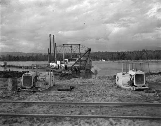
Today, they will probably use direction drilling to place the pipe; the old way shown in this photo made a huge mess, and is still used where the public would not care as much about their environment.


Thursday, March 6, 2014

Nevergreen Line

Local Tri-City News reports:   Concerns raised about Evergreen construction on creeks
I have been documenting the destruction locally for quite some time now, and the Evergreen Line, folks were always saying all will be fine, and why not? It is a large project, and a sensible person would think that environmental damage will be diminished as much as possible; since there is supposedly a large team in place to deal with any issues as they arise.  Apparently though public relations is the cheaper way out, since as I found out today and at other times, just in a very small area, attempts at mitigating pollution were very sparse to non-existent on the ground.  Have a look at these photos taken today (March 6, 2014) in a very small section of Scott Creek.

Also from the Tri-City News, Big plans for Brunette, Pinetree
   Sounds quite silly to me, to want to turn Pinetree into some sort of grand entrance, stage set.  We have lost considerable tree cover along Pinetree with all the Evergreen Line, construction going on; But we have lost considerably more along the Scott Creek corridor, and along the edges of the C.P.R. mainline, leading to Port Moody which was much more valuable to the wildlife that remains around here, but as usual out of sight, out of mind. The odds of a tree ever being anything along Pinetree are next to nil, when the elevated line is completed, since as soon as it grows up a little, out come the saws to keep it away from the elevated line.  Trees at least would have a chance along the Scott Creek, C.P.R. corridor.   Only small specimen types of trees, would  possibly do well along Pinetree, but the sad part is that small trees are easily vandalized, and the evidence of that is easy to be found in the immediate area.


Tuesday, March 4, 2014

Weather the erosional weather storms

The City of Coquitlam, in its long and labouring process of attempting to deal with primarily construction activity erosion events, due to weak knowledge and Erosion and Sediment Control bylaws with no clout.

    Have installed a weather station near the top of Coast Meridian Road, actually just down Harper Road, at the Water tank, and named it the Burke Mountain Rain Gauge   at least now they will have a  better idea eventually about how to size the construction ponds, to deal with the high rainfall events. Probably too little too late, since it takes years to gather up very relevant data. 

 Pitt Meadows weather forecast, from Environment Canada, is a useful tool, but it is on the lowlands, and does not reflect what is happening at higher elevations.

Environment Canada also has a gauge on Como Lake Avenue, installed in 1972.

Some historical data:
There has been 480 weather stations within 100Km., of Burnaby. Some operated many years ago, sometimes for just a few years, but they all tell a story.

Today in 2014 there is 26 weather stations still active within a 50 Km radius of Burnaby (missed the newer station on Burke in this listing though. )

So when someone says it was raining cats and dogs, you can now say no, it rained 22mm, yesterday with certainty.


Sunday, March 2, 2014

Widgeon Marsh park reserve, nest box cleaning

On Saturday from 2pm until 5:30pm, BMN members finally finished cleaning the bird boxes at Widgeon Marsh park reserve, after having to delay it from the week before because of snowy weather concerns.  The weather forecast was for sun in the morning changing to snow, and when we arrived at Widgeon the clouds were dropping quickly, and we were being occasionally dusted with very little snow, nothing to really bother us in our task at hand. Bird box usage was high as usual for this park, and we saw at least a hundred 90 Trumpeter swans off in the distance trumpeting occasionally in the slough.

Nice example of a duck-feather-lined nest.

The troops awaiting their marching orders, all seventeen of us a good number considering the previous weekends weather delay, after dividing into groups we wandered away and completed the tasks required with time to spare.

A few photos of the days adventure on Panoramio

The rarely seen and elusive untamed naturalists in their natural habitat
looking north Widgeon Creek valley
And some more pictures of the event along with previous outings to Widgeon Marsh


A picture of a picture-taking naturalist,  Photo: Hilary Maguire

And a list of the birds spotted, from Hilary Maguire
5 Canada Goose
90 Trumpeter Swan
21 Mallard
1 Bufflehead
1 Common Goldeneye
3 Bald Eagle
1 Northern Flicker
1 Steller's Jay
1 Pacific Wren
20 Golden-crowned Kinglet
2 Varied Thrush
2 Spotted Towhee

And Pamela Zevitt, added a song sparrow, and a belted kingfisher.
And also a collection of photos from Pamela of the adventure.

Also a photo set from a professional photographer, Paul Steeves.
But wait ! John (Jack) provided some more photos; Great..


        When we got to the site what appeared to be an eagle was soaring overhead, but difficult to identify; but in the group that I was with we were able to identify it a little later as a Golden eagle.

☞Thanks☜ to all the suppliers of pictures and information,
nice to know that many species use the area; including untamed naturalists.